The student of Scripture should always have a map open next to their Bible as they read. If possible, they should also travel to Israel, not to make a pilgrimage, but to see the context of the land in which these stories took place. These are not fairy tales made up about fictional fantasy lands; these are stories about real people in real places interacting with a real God.
One of the biggest anxieties for lay readers during Sunday morning worship services is pronouncing challenging proper nouns. A quick glance at a genealogy or tribal allotments is enough to understand just how hard it is to pronounce some of these ancient place names. (Who wants to read words like Beth-aven, Kiriath-jeraim, Nephtoah, Geliloth, Adummim, or Emek-keziz publicly?) In addition, many of these names are meaningless to people who live thousands of miles away, thousands of years after the events of the story, and in a completely different culture. The problem is made worse by the tendency of modern readers to tune out these confusing place names when reading, since they carry little to no meaning. This means that entire chunks of the story are entirely foreign to modern American readings of the biblical text. Reclaiming this knowledge is vital to understanding the biblical story, and the solution begins with something quite simple: look at a map.1 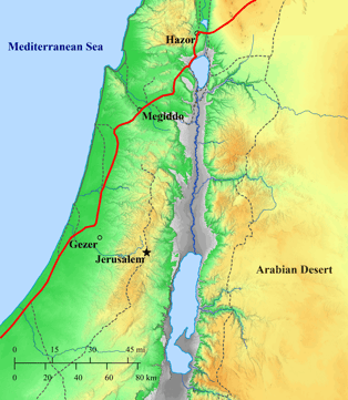
Israel’s geography determines much of the geopolitical events that plague the people of God. Understanding the 30,000-foot view is necessary to understand the decisions that individuals make. The Southern Levant is filled with hills, valleys, rivers, lakes, plains, and coastlands. These geographical features matter because they can affect annual rainfall and crop yields. This, in turn, determines which crops or animals people in various areas of Israel can harvest. Running right through the middle of ancient Israel is the Jordan River, with two lakes - the Dead Sea and the Sea of Galilee - at either end. To the west of this river, the land rises up into a mountain range that defines the landscape of over half of Israel. This mountain range creates a rain shadow that collects most of the water from the Mediterranean Sea. East of this Judean ridge, the climate is much drier. People who lived in this arid region of Israel often could not farm much and instead relied on herd animals. If a traveler moved east of these lands, they went from dry to really dry in the matter of a few miles. The Arabian Desert east of Israel is effectively impassable to any large army and most travelers. This meant that a narrow strip of land held by the Israelites was vital to international trade and to armies moving between Mesopotamia and Egypt.
Since Israel is part of a land bridge connecting Egypt with the rest of the ancient world, it was constantly caught in the power struggles among more powerful kingdoms and empires. To zoom in a bit closer, there is an international highway that runs from Egypt to Damascus right through Israel. This international coastal highway is sometimes identified as the “Way of the Sea,” as in Isaiah 9:1, and formed the major artery of trade and the route armies traveled in ancient times. The king who controlled this road could collect taxes, deter foreign militaries, and impose his will on international politics. Such a king also had to be exceptionally powerful to exert control over foreign powerhouses like Egypt or Assyria. It also meant that control over this road was extremely important to such a king; to lose control of this highway was to lose control of the whole kingdom.
This is the situation that Solomon finds himself in as he inherits his father David’s kingdom. David had united the tribes of Israel and forged Israel into a powerful kingdom. Solomon had a great starting position, but he needed to stay on top of the situation or he would be overwhelmed by foreign enemies. David had succeeded through warfare; Solomon chose a different path - he worked through diplomacy. In the ancient world, diplomacy was conducted through the exchange of wives, a practice known as political marriages. A king would send his daughter to marry another king, and the two rulers would become family. This would dissuade warfare between the two kingdoms. After all, one king now had a ready-made hostage in the case of hostilities. Solomon made abundant use of this form of diplomacy; 1 Kings 11:1-8 reports that he had 700 wives from many different kingdoms surrounding his own. The most prestigious wife was the daughter of Pharaoh. It is curious that the kings of Egypt almost never sent their daughters out of the country for such political marriages, but here Pharaoh does just that. This demonstrates just how powerful Solomon really was; even the mighty Pharaoh gave his daughter to Solomon in marriage (1 Kings 3:1).
What is particularly interesting about this marriage is the dowry that Pharaoh gives Solomon: the international coastal highway. In 1 Kings 9:15-19 the author is describing Solomon’s building projects, and he pauses to explicitly explain how Solomon acquired the city of Gezer. Gezer is a Canaanite city at the edge of the foothills leading up to the mountain stronghold of Jerusalem. It overlooks the north-south highway to the west and guards the pass through the Aijalon Valley, which runs east-west. To fulfill such an important function, this city was heavily fortified. But, according to 1 Kings 9, Pharaoh conquered it and razed it to the ground. By attacking this city, Pharaoh cleared the way for Solomon, his new son-in-law, to rebuild it and establish a string of forts along the international highway to collect taxes and protect it.
This is, in fact, what Solomon does. 1 Kings 9 states that Solomon built the walls of Jerusalem, Hazor, Megiddo, and Gezer. These last three cities sit in strategic locations along the international coastal highway, and all three have fortifications dating to the time of Solomon. In fact, Solomon used a specific kind of defensive fortification called the six-cambered gate. Archaeological excavations at each site have revealed these gates, and this style is now known as “Solomonic Gates.”2
All of this lurks under the surface of 1 Kings 3-11 to a modern audience to those who know the geography, the story becomes much more impactful. In 1 Kings 11, Solomon’s wives turn his heart from Yahweh to other gods, and he breaks the first commandment. But what set him on that path were the political marriages that were necessary because of the international road. If Pharaoh could conquer Gezer and then give it to Solomon, who is to say he cannot take it back? Solomon has a choice: to trust Yahweh to protect him and his kingdom, or to trust his alliances with foreign kings. His seven hundred wives seem to answer that question. They turned his heart from Yahweh, and he placed his trust in them, their gods, and their fathers and brothers.
Trusting Yahweh is often risky and fraught with danger. God’s way is not man’s way, and to trust him means letting go and letting him control the world around us. It often feels safer to make alliances, build fortified cities, and prepare armies for battle than to turn to God when things get tough. But this is the choice of Gezer: to trust God or to trust man. This is not just a choice Solomon had to make; it's something that every Christian has to grapple with, too. Every Christian must choose: “Will I trust God to justify me and save me? Or will I take matters into my own hands to save myself?” One is filled with promise and hope, the other with certain doom.
Geography and archaeology help illuminate the challenging choices Solomon had to make. The weird, hard-to-pronounce words are filled with meaning that should not be ignored or skipped over. The student of Scripture should always have a map open next to their Bible as they read. Ideally, and if possible, they should also travel to Israel, not to make a pilgrimage, but to see the context of the land in which these stories took place. These are not fairy tales made up about fictional fantasy lands; these are stories about real people in real places interacting with a real God. The geography matters.
Notes
1. Map created with Bible Mapper (biblemapper.com).
2. See A. Mazar, Archaeology of the Land of the Bible – 10,000-586 BCE (New York: Doubleday, 1990), 380-384.